


Mapa antiguo de Escandinavia de Bartholomew, 1871: Estocolmo, Copenhague, Oslo, mar Báltico, Montes Escandinavos
La oferta del coleccionista
Elija dos obras elegibles y obtenga un 20 % de descuento en ambas. Elija tres y la de menor precio será gratuita, con un ahorro máximo del 33 %.
Combine y mezcle mapas estándar elegibles y reproducciones de bellas artes. No se requiere código; la oferta se aplica automáticamente al finalizar la compra.
Se incluyen las configuraciones estándar hechas por encargo. Quedan excluidos los tamaños a medida, los diseños personalizados y los trabajos por encargo.
¿Necesita entrega en diferentes direcciones? Contáctenos antes de realizar el pedido.La oferta del coleccionista
Elija dos obras elegibles y obtenga un 20 % de descuento en ambas. Elija tres y la de menor precio será gratuita, con un ahorro máximo del 33 %.
Combine y mezcle mapas estándar elegibles y reproducciones de bellas artes. No se requiere código; la oferta se aplica automáticamente al finalizar la compra.
Se incluyen las configuraciones estándar hechas por encargo. Quedan excluidos los tamaños a medida, los diseños personalizados y los trabajos por encargo.
¿Necesita entrega en diferentes direcciones? Contáctenos antes de realizar el pedido. Diseñado en Londres Hecho en la UE
Diseñado en Londres • Hecho en la UE
Diseñado en Londres Hecho en la UE
Diseñado en Londres • Hecho en la UE

Restaurado a partir del mapa original de 1871 e impreso en calidad museo. Leer la historia detrás de este mapa
Choose your size
Choose your finish


(Más información)
Mensaje de regalo y acabado personalizado

Si deseas agregar un mensaje de regalo, o un acabado (rompecabezas, tablero de aluminio, etc.) que no esté disponible aquí, por favor solicítalo en la "nota del pedido" cuando realices la compra.
Cada pedido es hecho a medida, así que si necesitas que el tamaño se ajuste ligeramente, o que se imprima en un material inusual, háznoslo saber. Hemos realizado miles de pedidos personalizados a lo largo de los años, así que hay (casi) nada que no podamos gestionar.
También puedes contactarnos antes de hacer tu pedido, ¡si lo prefieres!

- Hecho localmente. Entrega segura
- Sin aranceles ni cargos ocultos
- ¿Necesitas ayuda? Llámanos o mensaje por WhatsApp
Own a piece of history
8,000+ five-star reviews


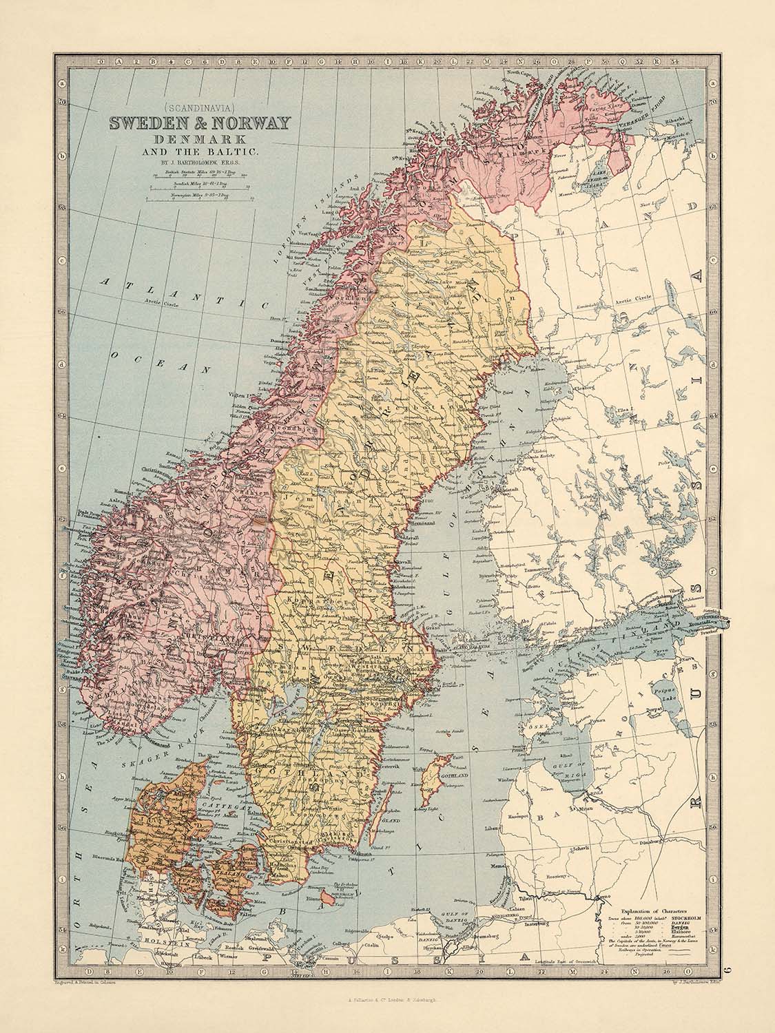
Adéntrese en el cautivador mundo de la cartografía del siglo XIX con el mapa original de 1871 titulado “(Scandinavia) Sweden & Norway,...
Seguir leyendoAdéntrese en el cautivador mundo de la cartografía del siglo XIX con el mapa original de 1871 titulado “(Scandinavia) Sweden & Norway, Denmark, and the Baltic,” una obra maestra del estimado cartógrafo escocés John Bartholomew. Este grabado coloreado a mano, de doble página, fue creado durante un período de gran curiosidad y precisión geográfica, reflejando la búsqueda de la época por documentar y comprender el intrincado tapiz del norte de Europa. El mapa de Bartholomew no es meramente una herramienta de navegación; es una narrativa visual que une con elegancia los paisajes políticos y físicos de Suecia, Noruega, Dinamarca y la región báltica circundante, ofreciendo una visión detallada del mundo administrativo y natural tal como se entendía a finales de la era victoriana.
John Bartholomew, Jr., la mente visionaria detrás de este mapa, fue un pionero en el arte y la ciencia de la cartografía. Sobre la base del legado de la célebre firma cartográfica de su padre en Edimburgo, Bartholomew introdujo técnicas innovadoras de contorno en color para señalar la altitud, una práctica que más tarde se convertiría en estándar en la disciplina. Su trabajo se caracterizó por el compromiso tanto con la precisión como con la estética, como lo evidencian las minuciosas hachuras del mapa, que dan vida a las Montañas Escandinavas (Scandes) y a otros terrenos abruptos. La alineación del mapa con el meridiano de Greenwich subraya aún más la dedicación de Bartholomew a los estándares de navegación contemporáneos y a la conectividad global.
Este mapa es un rico tableau de las características naturales y políticas de la región. Las sinuosas costas del mar Báltico, los espectaculares fiordos de Noruega y los extensos lagos de Suecia —como Vänern y Vättern— están representados con excepcional claridad. Los principales ríos, canales y la intrincada red de caminos atraviesan el paisaje, mientras que las fronteras entre Suecia, Noruega y Dinamarca están nítidamente delimitadas, reflejando las realidades políticas de la época. La representación de los estrechos y vías navegables clave, incluidos Skagerrak, Kattegat y Øresund, destaca la importancia marítima estratégica de la región, conectando el mar del Norte con el corazón del Báltico.
Más allá de sus maravillas naturales, el mapa es un vibrante registro del asentamiento humano y la ambición. Ciudades como Estocolmo, Copenhague, Oslo (entonces Christiania), Gotemburgo y Bergen destacan como faros de comercio, cultura y gobierno. Localidades más pequeñas y centros regionales —desde Uppsala y Malmö en Suecia hasta Aarhus y Odense en Dinamarca— están meticulosamente situados, ofreciendo una fascinante instantánea del desarrollo urbano en el siglo XIX. Cada asentamiento se ubica dentro de su contexto provincial o condal, proporcionando una comprensión estratificada de la estructura administrativa de la región y de la interacción entre geografía y sociedad.
Históricamente, este mapa es una ventana a una era transformadora para Escandinavia y el Báltico, un tiempo en el que se forjaban identidades nacionales y se negociaban cuidadosamente las fronteras. Fue publicado como parte del célebre “Descriptive Hand Atlas of the World” de Fullarton, un compendio diseñado para educar e inspirar, repleto de tablas estadísticas y comentarios perspicaces. Hoy, el mapa de Bartholomew perdura tanto como recurso académico como obra de arte, un testimonio perdurable de la meticulosa artesanía, el rigor científico y la sensibilidad estética que definieron una de las edades de oro de la cartografía.
Ciudades y pueblos en este mapa
- Suecia
- Estocolmo
- Gotemburgo (Göteborg)
- Malmö
- Uppsala
- Västerås
- Örebro
- Linköping
- Helsingborg
- Norrköping
- Jönköping
- Lund
- Gävle
- Borås
- Eskilstuna
- Sundsvall
- Karlstad
- Halmstad
- Växjö
- Karlskrona
- Luleå
- Kristianstad
- Skövde
- Trollhättan
- Södertälje
- Kalmar
- Falun
- Östersund
- Umeå
-
Visby
-
Noruega
- Oslo (Christiania/Kristiania)
- Bergen
- Stavanger
- Trondheim (Trondhjem)
- Drammen
- Fredrikstad
- Kristiansand
- Tromsø
- Ålesund
- Bodø
-
Hamar
-
Dinamarca
- Copenhague (Kjøbenhavn)
- Aarhus (Aarhuus)
- Odense
- Aalborg (Aalborg)
- Esbjerg
- Randers
- Kolding
- Horsens
- Vejle
- Roskilde
- Helsingør
Características y puntos de interés destacados
- Mar Báltico
- Golfo de Botnia
- Golfo de Finlandia
- Mar del Norte
- Skagerrak
- Kattegat
- Øresund (El Sund)
- Grandes lagos (p. ej., Vänern, Vättern en Suecia, Mjøsa en Noruega)
- Fronteras internacionales entre Suecia, Noruega, Dinamarca y regiones vecinas
- Límites provinciales y condales internos dentro de Suecia y Noruega
- Montes Escandinavos (Scandes)
- Hachuras utilizadas para indicar terrenos montañosos y elevados
- Meridiano principal indicado en Greenwich
- Ríos y canales claramente señalados
- Litorales e islas detallados en el mar Báltico y el mar del Norte
Contexto histórico y de diseño
- Creado en 1871 por John Bartholomew, reconocido cartógrafo escocés
- Publicado como parte del “Descriptive Hand Atlas of the World” de Fullarton
- Mapa grabado, coloreado a mano y de doble página, con una artesanía meticulosa
- Uso innovador del contorno cromático para denotar elevaciones, pionero de Bartholomew
- Relieve ilustrado mediante hachuras para lograr un efecto tridimensional del terreno
- Meridiano principal fijado en Greenwich, en consonancia con los estándares de navegación del siglo XIX
- Representación exhaustiva de divisiones políticas y administrativas, incluidos límites, provincias y condados
- Rico conjunto de elementos naturales y políticos que refleja la Europa septentrional de finales del siglo XIX
- Parte de un atlas célebre diseñado para educar e inspirar, con descripciones y tablas estadísticas complementarias
- Una pieza de colección que ejemplifica la edad de oro de la cartografía
Por favor, compruebe detenidamente las imágenes para asegurarse de que una ciudad o lugar específico aparece en este mapa. También puede ponerse en contacto con nosotros y pedirnos que revisemos el mapa por usted.
Este mapa luce великолепente a cualquier tamaño, pero siempre recomiendo optar por un tamaño mayor si dispone de espacio. Así podrá apreciar con facilidad todos los detalles.
Este mapa luce increíble en tamaños de hasta 50in (125cm). Si busca un mapa más grande, por favor póngase en contacto.
El modelo en las imágenes del anuncio sostiene la versión de 18x24in (45x60cm) de este mapa.
La quinta imagen del anuncio muestra un ejemplo de mi servicio de personalización de mapas.
Si busca algo ligeramente diferente, eche un vistazo a mi colección de los mejores mapas antiguos para ver si algo más le llama la atención.
Por favor contácteme para comprobar si se muestra una determinada ubicación, hito o característica en este mapa.
Esto sería un maravilloso regalo de cumpleaños, Navidad, Día del Padre, despedida del trabajo, aniversario o inauguración de casa para alguien de las zonas cubiertas por este mapa.
Este mapa está disponible como impresión giclée en papel mate de archivo libre de ácido, o puede adquirirlo enmarcado. El marco es un marco negro, sencillo y elegante, que se adapta a la mayoría de las estéticas. Póngase en contacto si desea un color o material de marco diferente. Mis marcos están acristalados con acrílico de grado museo de superalta claridad (perspex/acrylite), que es mucho menos reflectante que el vidrio, más seguro y siempre llegará en perfectas condiciones.
This map is also available as a float framed canvas, sometimes known as a shadow gap framed canvas or canvas floater. The map is printed on artist's cotton canvas and then stretched over a handmade box frame. We then "float" the canvas inside a wooden frame, which is available in a range of colours (black, dark brown, oak, antique gold and white). This is a wonderful way to present a map without glazing in front. See some examples of float framed canvas maps and explore the differences between my different finishes.
For something truly unique, this map is also available in "Unique 3D", our trademarked process that dramatically transforms the map so that it has a wonderful sense of depth. We combine the original map with detailed topography and elevation data, so that mountains and the terrain really "pop". For more info and examples of 3D maps, check my Unique 3D page.
Adéntrese en el cautivador mundo de la cartografía del siglo XIX con el mapa original de 1871 titulado “(Scandinavia) Sweden & Norway, Denmark, and the Baltic,” una obra maestra del estimado cartógrafo escocés John Bartholomew. Este grabado coloreado a mano, de doble página, fue creado durante un período de gran curiosidad y precisión geográfica, reflejando la búsqueda de la época por documentar y comprender el intrincado tapiz del norte de Europa. El mapa de Bartholomew no es meramente una herramienta de navegación; es una narrativa visual que une con elegancia los paisajes políticos y físicos de Suecia, Noruega, Dinamarca y la región báltica circundante, ofreciendo una visión detallada del mundo administrativo y natural tal como se entendía a finales de la era victoriana.
John Bartholomew, Jr., la mente visionaria detrás de este mapa, fue un pionero en el arte y la ciencia de la cartografía. Sobre la base del legado de la célebre firma cartográfica de su padre en Edimburgo, Bartholomew introdujo técnicas innovadoras de contorno en color para señalar la altitud, una práctica que más tarde se convertiría en estándar en la disciplina. Su trabajo se caracterizó por el compromiso tanto con la precisión como con la estética, como lo evidencian las minuciosas hachuras del mapa, que dan vida a las Montañas Escandinavas (Scandes) y a otros terrenos abruptos. La alineación del mapa con el meridiano de Greenwich subraya aún más la dedicación de Bartholomew a los estándares de navegación contemporáneos y a la conectividad global.
Este mapa es un rico tableau de las características naturales y políticas de la región. Las sinuosas costas del mar Báltico, los espectaculares fiordos de Noruega y los extensos lagos de Suecia —como Vänern y Vättern— están representados con excepcional claridad. Los principales ríos, canales y la intrincada red de caminos atraviesan el paisaje, mientras que las fronteras entre Suecia, Noruega y Dinamarca están nítidamente delimitadas, reflejando las realidades políticas de la época. La representación de los estrechos y vías navegables clave, incluidos Skagerrak, Kattegat y Øresund, destaca la importancia marítima estratégica de la región, conectando el mar del Norte con el corazón del Báltico.
Más allá de sus maravillas naturales, el mapa es un vibrante registro del asentamiento humano y la ambición. Ciudades como Estocolmo, Copenhague, Oslo (entonces Christiania), Gotemburgo y Bergen destacan como faros de comercio, cultura y gobierno. Localidades más pequeñas y centros regionales —desde Uppsala y Malmö en Suecia hasta Aarhus y Odense en Dinamarca— están meticulosamente situados, ofreciendo una fascinante instantánea del desarrollo urbano en el siglo XIX. Cada asentamiento se ubica dentro de su contexto provincial o condal, proporcionando una comprensión estratificada de la estructura administrativa de la región y de la interacción entre geografía y sociedad.
Históricamente, este mapa es una ventana a una era transformadora para Escandinavia y el Báltico, un tiempo en el que se forjaban identidades nacionales y se negociaban cuidadosamente las fronteras. Fue publicado como parte del célebre “Descriptive Hand Atlas of the World” de Fullarton, un compendio diseñado para educar e inspirar, repleto de tablas estadísticas y comentarios perspicaces. Hoy, el mapa de Bartholomew perdura tanto como recurso académico como obra de arte, un testimonio perdurable de la meticulosa artesanía, el rigor científico y la sensibilidad estética que definieron una de las edades de oro de la cartografía.
Ciudades y pueblos en este mapa
- Suecia
- Estocolmo
- Gotemburgo (Göteborg)
- Malmö
- Uppsala
- Västerås
- Örebro
- Linköping
- Helsingborg
- Norrköping
- Jönköping
- Lund
- Gävle
- Borås
- Eskilstuna
- Sundsvall
- Karlstad
- Halmstad
- Växjö
- Karlskrona
- Luleå
- Kristianstad
- Skövde
- Trollhättan
- Södertälje
- Kalmar
- Falun
- Östersund
- Umeå
-
Visby
-
Noruega
- Oslo (Christiania/Kristiania)
- Bergen
- Stavanger
- Trondheim (Trondhjem)
- Drammen
- Fredrikstad
- Kristiansand
- Tromsø
- Ålesund
- Bodø
-
Hamar
-
Dinamarca
- Copenhague (Kjøbenhavn)
- Aarhus (Aarhuus)
- Odense
- Aalborg (Aalborg)
- Esbjerg
- Randers
- Kolding
- Horsens
- Vejle
- Roskilde
- Helsingør
Características y puntos de interés destacados
- Mar Báltico
- Golfo de Botnia
- Golfo de Finlandia
- Mar del Norte
- Skagerrak
- Kattegat
- Øresund (El Sund)
- Grandes lagos (p. ej., Vänern, Vättern en Suecia, Mjøsa en Noruega)
- Fronteras internacionales entre Suecia, Noruega, Dinamarca y regiones vecinas
- Límites provinciales y condales internos dentro de Suecia y Noruega
- Montes Escandinavos (Scandes)
- Hachuras utilizadas para indicar terrenos montañosos y elevados
- Meridiano principal indicado en Greenwich
- Ríos y canales claramente señalados
- Litorales e islas detallados en el mar Báltico y el mar del Norte
Contexto histórico y de diseño
- Creado en 1871 por John Bartholomew, reconocido cartógrafo escocés
- Publicado como parte del “Descriptive Hand Atlas of the World” de Fullarton
- Mapa grabado, coloreado a mano y de doble página, con una artesanía meticulosa
- Uso innovador del contorno cromático para denotar elevaciones, pionero de Bartholomew
- Relieve ilustrado mediante hachuras para lograr un efecto tridimensional del terreno
- Meridiano principal fijado en Greenwich, en consonancia con los estándares de navegación del siglo XIX
- Representación exhaustiva de divisiones políticas y administrativas, incluidos límites, provincias y condados
- Rico conjunto de elementos naturales y políticos que refleja la Europa septentrional de finales del siglo XIX
- Parte de un atlas célebre diseñado para educar e inspirar, con descripciones y tablas estadísticas complementarias
- Una pieza de colección que ejemplifica la edad de oro de la cartografía
Por favor, compruebe detenidamente las imágenes para asegurarse de que una ciudad o lugar específico aparece en este mapa. También puede ponerse en contacto con nosotros y pedirnos que revisemos el mapa por usted.
Este mapa luce великолепente a cualquier tamaño, pero siempre recomiendo optar por un tamaño mayor si dispone de espacio. Así podrá apreciar con facilidad todos los detalles.
Este mapa luce increíble en tamaños de hasta 50in (125cm). Si busca un mapa más grande, por favor póngase en contacto.
El modelo en las imágenes del anuncio sostiene la versión de 18x24in (45x60cm) de este mapa.
La quinta imagen del anuncio muestra un ejemplo de mi servicio de personalización de mapas.
Si busca algo ligeramente diferente, eche un vistazo a mi colección de los mejores mapas antiguos para ver si algo más le llama la atención.
Por favor contácteme para comprobar si se muestra una determinada ubicación, hito o característica en este mapa.
Esto sería un maravilloso regalo de cumpleaños, Navidad, Día del Padre, despedida del trabajo, aniversario o inauguración de casa para alguien de las zonas cubiertas por este mapa.
Este mapa está disponible como impresión giclée en papel mate de archivo libre de ácido, o puede adquirirlo enmarcado. El marco es un marco negro, sencillo y elegante, que se adapta a la mayoría de las estéticas. Póngase en contacto si desea un color o material de marco diferente. Mis marcos están acristalados con acrílico de grado museo de superalta claridad (perspex/acrylite), que es mucho menos reflectante que el vidrio, más seguro y siempre llegará en perfectas condiciones.
This map is also available as a float framed canvas, sometimes known as a shadow gap framed canvas or canvas floater. The map is printed on artist's cotton canvas and then stretched over a handmade box frame. We then "float" the canvas inside a wooden frame, which is available in a range of colours (black, dark brown, oak, antique gold and white). This is a wonderful way to present a map without glazing in front. See some examples of float framed canvas maps and explore the differences between my different finishes.
For something truly unique, this map is also available in "Unique 3D", our trademarked process that dramatically transforms the map so that it has a wonderful sense of depth. We combine the original map with detailed topography and elevation data, so that mountains and the terrain really "pop". For more info and examples of 3D maps, check my Unique 3D page.
Many of our maps and art prints are chosen as thoughtful gifts for homes, offices, studies and meaningful places.
Choose a framed option for the easiest ready-to-hang gift, or choose an unframed print if the recipient may prefer to select their own frame.
We make orders locally in 23 countries around the world, so gifts can often be produced close to the recipient. This helps them arrive faster, travel more safely, and avoid customs or import duty surprises.
- We can deliver directly to the recipient
- Framed pieces arrive ready to hang
- Unframed prints are carefully packed in a strong protective tube
- Almost every order is made locally, for faster, safer gifting
- 90-day returns give the recipient time to decide
If you are not sure what to choose, please contact us. We can help you pick the right map, size, finish or delivery option.
Para la mayoría de los pedidos, el tiempo de entrega es de aproximadamente 3 días laborables. Los productos personalizados y a medida tardan más, ya que tengo que hacer la personalización y enviártelo para su aprobación, lo cual suele tardar 1 o 2 días.
Tenga en cuenta que los pedidos enmarcados muy grandes suelen tardar más en fabricarse y entregarse.
Si necesitas que tu pedido llegue para una fecha determinada, por favor contáctame antes de hacer el pedido para que podamos encontrar la mejor manera de asegurarnos de que recibas tu pedido a tiempo.
Imprimo y enmarco mapas y obras de arte en 23 países alrededor del mundo. Esto significa que tu pedido se fabricará localmente, lo que reduce el tiempo de entrega y asegura que no se dañe durante el envío. Nunca pagarás aranceles de aduana o impuestos de importación, y pondremos menos CO2 en el aire.
Todos mis mapas y impresiones artísticas están bien empaquetados y enviados en un tubo resistente si no están enmarcados, o rodeados de espuma si están enmarcados.
Intento enviar todos los pedidos dentro de 1 o 2 días después de recibir tu pedido, aunque algunos productos (como mascarillas, tazas y bolsas de tela) pueden tardar más en fabricarse.
Si seleccionas Entrega Exprés al finalizar la compra, priorizaremos tu pedido y lo enviaremos por mensajería de 1 día (Fedex, DHL, UPS, Parcelforce).
La entrega al día siguiente también está disponible en algunos países (EE. UU., Reino Unido, Singapur, EAU), pero por favor intenta hacer tu pedido temprano en el día para que podamos enviarlo a tiempo.
Mi marco estándar es un marco de madera de fresno negro estilo galería. Es simple y tiene un aspecto bastante moderno. Mi marco estándar tiene alrededor de 20 mm (0.8 in) de ancho.
Utilizo acrílico super claro (perspex/acrylite) para el vidrio del marco. Es más ligero y seguro que el vidrio, y se ve mejor, ya que la reflectividad es menor.
Seis colores de marco estándar están disponibles de forma gratuita (negro, marrón oscuro, gris oscuro, roble, blanco y oro antiguo).El enmarcado y montaje/matizado personalizado está disponible si buscas algo diferente.
La mayoría de los mapas, arte e ilustraciones también están disponibles como un lienzo enmarcado. Utilizamos lienzo de algodón mate (no brillante), lo estiramos sobre un marco de madera de caja de origen sostenible, y luego 'flotamos' la pieza dentro de un marco de madera. El resultado final es bastante hermoso, y no hay cristal que se interponga.
Todos los marcos se proporcionan "listos para colgar", con una cuerda o soportes en la parte posterior. Los marcos muy grandes tendrán placas de colgar de alta resistencia y/o un listón de montaje. Si tienes alguna pregunta, por favor ponte en contacto.
Mira algunos ejemplos de mis mapas enmarcados y mapas en lienzo enmarcados.
Alternativamente, también puedo proporcionar mapas antiguos y obras de arte en lienzo, tablero de espuma, papel de algodón y otros materiales.
Si deseas enmarcar tu mapa o obra de arte tú mismo, por favor lee mi guía de tamaños primero.
Mis mapas son reproducciones de mapas originales de altísima calidad.
Obtengo mapas originales y raros de bibliotecas, casas de subastas y colecciones privadas de todo el mundo, los restauro en mi taller de Londres y luego uso tintas e impresoras giclée especializadas para crear hermosos mapas que lucen incluso mejor que el original.
Mis mapas están impresos en papel de archivo mate (no brillante) sin ácido que se siente de muy alta calidad y casi como una tarjeta. En términos técnicos, el peso/grosor del papel es de 10 mil/200 g/m². Es perfecto para enmarcar.
Imprimo con tintas pigmentadas Epson ultrachrome giclée UV resistentes a la decoloración, algunas de las mejores tintas que puedes encontrar.
yo también puedo hacer mapas sobre lienzo, trapo de algodón y otros materiales exóticos.
Obtenga más información sobre The Unique Maps Co..
Personalización de mapas
Si está buscando el regalo perfecto de aniversario o inauguración de la casa, puedo personalizar su mapa para hacerlo verdaderamente único. Por ejemplo, puedo agregar un mensaje corto, resaltar una ubicación importante o agregar el escudo de armas de su familia.
Las opciones son casi infinitas. Por favor mira mi página de personalización de mapas para ver algunos maravillosos ejemplos de lo que es posible.
Para pedir un mapa personalizado, seleccione "personalizar su mapa" antes de agregarlo a su carrito.
Ponerse en contacto si buscas personalizaciones y personalizaciones más complejas.
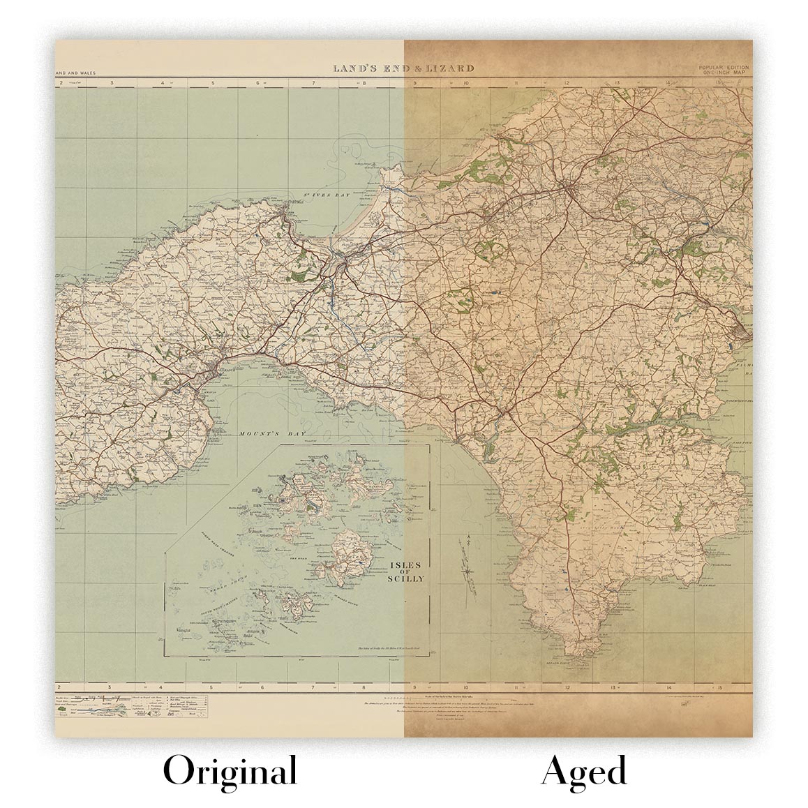
Envejecimiento del mapa
A lo largo de los años, los clientes me han preguntado cientos de veces si podían comprar un mapa que se viera uniforme. más viejo.
Bueno, ahora puedes hacerlo seleccionando Envejecido antes de agregar un mapa a tu carrito.
Todas las fotografías de productos que ve en esta página muestran el mapa en su forma original. Así es como se ve el mapa hoy.
Si selecciona Envejecido, envejeceré su mapa a mano, usando un proceso especial y único desarrollado a través de años de estudiar mapas antiguos, hablar con investigadores para comprender la química del envejecimiento del papel y, por supuesto... ¡mucha práctica!
Si no estás seguro, quédate con el color original del mapa. Si quieres algo un poco más oscuro y más viejo buscando, opte por Envejecido.
Si no estás satisfecho con tu pedido por cualquier motivo, contáctame para un reembolso sin complicaciones. Por favor, consulta nuestra política de devoluciones y reembolsos para más información.
Estoy muy seguro de que te gustará tu mapa o impresión artística restaurada. He estado haciendo esto desde 1984. Soy un vendedor de 5 estrellas en Etsy. He vendido decenas de miles de mapas e impresiones artísticas y tengo más de 5,000 opiniones reales de 5 estrellas.
Utilizo un proceso único para restaurar mapas y obras de arte que consume mucho tiempo y mano de obra. Buscar los mapas e ilustraciones originales puede llevar meses. Utilizo tecnología de última generación y extremadamente cara para escanear y restaurarlos. Como resultado, garantizo que mis mapas e impresiones artísticas son superiores a los demás - por eso puedo ofrecer un reembolso sin complicaciones.
Casi todos mis mapas e impresiones artísticas se ven increíbles en tamaños grandes (200cm, 6.5ft+) y también puedo enmarcarlos y entregártelos a través de un servicio de mensajería especial para tamaños grandes. Contáctame para discutir tus necesidades específicas.
Or try searching for something!


