


Primer mapa de Nueva Inglaterra de John Smith, 1616: Boston, Plymouth, Cabo Ann, diseño barroco ornamentado
La oferta del coleccionista
Elija dos obras elegibles y obtenga un 20 % de descuento en ambas. Elija tres y la de menor precio será gratuita, con un ahorro máximo del 33 %.
Combine y mezcle mapas estándar elegibles y reproducciones de bellas artes. No se requiere código; la oferta se aplica automáticamente al finalizar la compra.
Se incluyen las configuraciones estándar hechas por encargo. Quedan excluidos los tamaños a medida, los diseños personalizados y los trabajos por encargo.
¿Necesita entrega en diferentes direcciones? Contáctenos antes de realizar el pedido.La oferta del coleccionista
Elija dos obras elegibles y obtenga un 20 % de descuento en ambas. Elija tres y la de menor precio será gratuita, con un ahorro máximo del 33 %.
Combine y mezcle mapas estándar elegibles y reproducciones de bellas artes. No se requiere código; la oferta se aplica automáticamente al finalizar la compra.
Se incluyen las configuraciones estándar hechas por encargo. Quedan excluidos los tamaños a medida, los diseños personalizados y los trabajos por encargo.
¿Necesita entrega en diferentes direcciones? Contáctenos antes de realizar el pedido. Diseñado en Londres Hecho en la UE
Diseñado en Londres • Hecho en la UE
Diseñado en Londres Hecho en la UE
Diseñado en Londres • Hecho en la UE

Restaurado a partir del mapa original de 1616 e impreso en calidad museo. Leer la historia detrás de este mapa
Choose your size
Choose your finish


(Más información)
Mensaje de regalo y acabado personalizado

Si deseas agregar un mensaje de regalo, o un acabado (rompecabezas, tablero de aluminio, etc.) que no esté disponible aquí, por favor solicítalo en la "nota del pedido" cuando realices la compra.
Cada pedido es hecho a medida, así que si necesitas que el tamaño se ajuste ligeramente, o que se imprima en un material inusual, háznoslo saber. Hemos realizado miles de pedidos personalizados a lo largo de los años, así que hay (casi) nada que no podamos gestionar.
También puedes contactarnos antes de hacer tu pedido, ¡si lo prefieres!

- Hecho localmente. Entrega segura
- Sin aranceles ni cargos ocultos
- ¿Necesitas ayuda? Llámanos o mensaje por WhatsApp
Own a piece of history
8,000+ five-star reviews


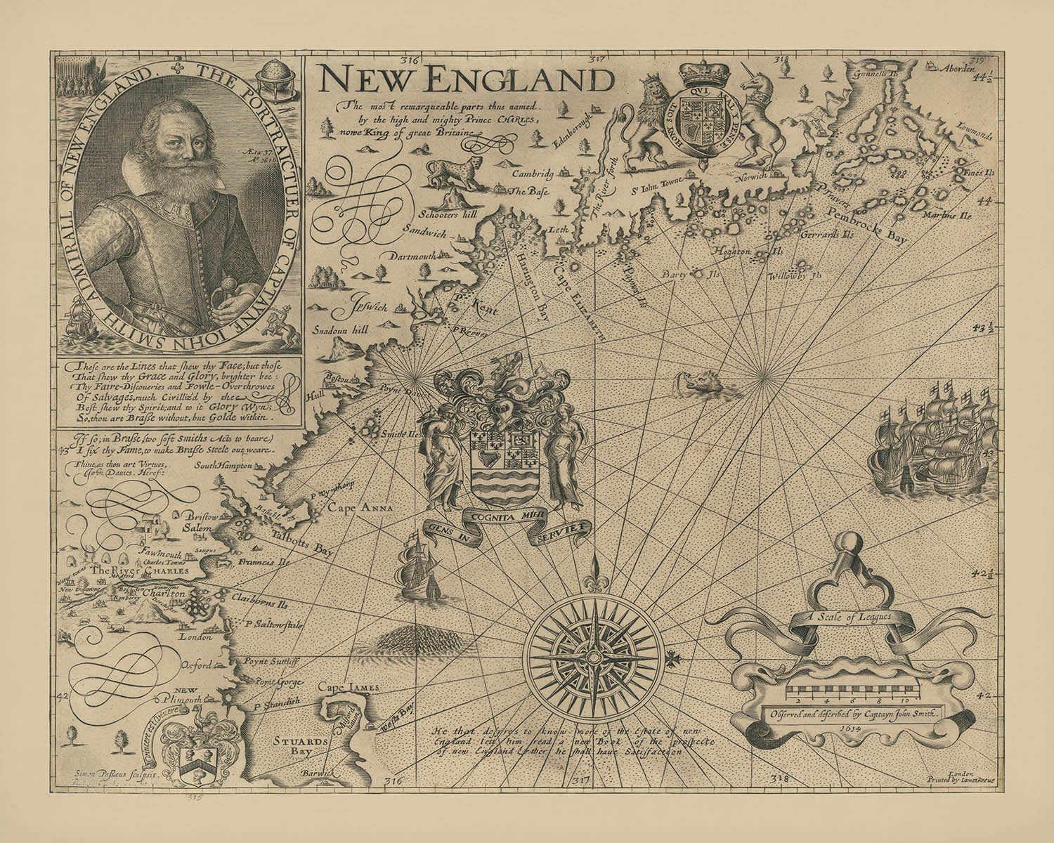
Adéntrese en los albores de la cartografía americana con “New England The most remarqueable parts thus named by the high and mighty...
Seguir leyendoAdéntrese en los albores de la cartografía americana con “New England The most remarqueable parts thus named by the high and mighty Prince Charles, nowe King of great Britaine. Observed and described by Captayn John Smith.” Creado en 1616, este mapa es ampliamente considerado la base de la cartografía de Nueva Inglaterra y el primero en dedicarse por completo a esta célebre región. Fue aquí, gracias a la mano experta y al agudo ojo del capitán John Smith, donde se concedió por primera vez el propio nombre de “New England”, alterando para siempre el panorama geográfico y cultural del continente. El título original del mapa, testimonio del patronazgo y la ambición reales, señala su posición única en la intersección de la exploración, la política y el arte.
El capitán John Smith, célebre por sus hazañas anteriores en Virginia, fue comisionado por mercaderes londinenses para explorar la misteriosa costa norte más allá de las colonias establecidas. Insatisfecho con la inexactitud de las cartas existentes, Smith emprendió su propio levantamiento, trazando con meticulosidad la costa, los ríos y los promontorios. Su dedicación a la exactitud es evidente en cada detalle, desde la cuidadosa delineación de la escarpada costa de Nueva Inglaterra hasta la destacada ubicación de grandes ríos como el Charles. La obra resultante no solo ofreció una guía práctica para futuros exploradores y colonos, sino que también sirvió como una persuasiva invitación a la inversión y colonización inglesas.
La calidad artística del mapa es tan notable como su precisión cartográfica. Grabado por Simon de Passe, un maestro artista neerlandés que trabajaba en Londres, el mapa está adornado con una serie de elementos decorativos que reflejan la grandiosidad de la era barroca. Un impactante retrato de John Smith ancla la composición, mientras que la ornamentada “escala de leguas” y la elaborada rosa de los vientos muestran el uso innovador que de Passe hizo del estilo auricular, un rasgo temprano distintivo del diseño barroco. Las armas del Council for New England, con su lema latino “GENS INCOGNITA MIHI SERVIET,” añaden un toque de autoridad y ambición a la extensión costera.
Este mapa captura un momento crucial de la historia, cuando la corona inglesa —a través de la influencia del príncipe Charles, posteriormente rey Carlos I— impuso nuevos nombres e identidades sobre el paisaje americano. Varios de estos nombres, entre ellos Cape Anne, Charles River y Plymouth, perduran hasta hoy, marcando el legado duradero del trabajo de Smith. La cuidadosa ubicación de Boston y la primera aparición de Charlestown reflejan su papel en la configuración de la geografía urbana de la región, mientras que su evocadora representación de bahías, islas y ríos insinúa la belleza indómita que aguardaba a los primeros colonos.
Más allá de sus logros técnicos y artísticos, el mapa de Smith se alza como símbolo de ambición, curiosidad y espíritu de descubrimiento. Es un vínculo tangible con los primeros días de la América inglesa, una época en la que aún se trazaban las fronteras del mundo, y cada curva de un río o promontorio costero encerraba la promesa de nuevos comienzos. Para coleccionistas, historiadores y amantes de la exploración, este mapa no es meramente un artefacto; es una invitación a viajar de regreso a los orígenes mismos de Nueva Inglaterra.
Cities and towns on this map
- Boston
- Charlestown
- Plymouth
Notable Features & Landmarks
- Las armas del Council for New England con el lema en latín "GENS INCOGNITA MIHI SERVIET" mar adentro de Cape Anna
- Una gran rosa de los vientos ornamentada
- Una cartela decorativa con el título y la dedicatoria del mapa
- Retrato del capitán John Smith con la fecha "Ao 1616"
- La « escala de leguas » con elaborada decoración barroca auricular
- Ríos principales, incluido el río Charles
- Cabo Anne (hoy Cape Ann)
- La costa de Nueva Inglaterra, incluyendo bahías, cabos e islas
- Una nota bajo la rosa de los vientos: «He that desyres to know more of the Estate of new England lett him read a new Book of the prospecte of new England & ther he shall haue Satissfaction»
Contexto histórico y de diseño
- Creado en 1616 por el capitán John Smith, célebre explorador y cartógrafo
- Grabado por Simon de Passe, un renombrado grabador neerlandés que trabajaba en Londres
- El primer mapa dedicado exclusivamente a la región de Nueva Inglaterra y considerado la base de la cartografía de Nueva Inglaterra
- Introdujo el nombre «Nueva Inglaterra» e incluyó topónimos proporcionados por Carlos, Príncipe de Gales (más tarde Carlos I)
- Corrigió errores cartográficos anteriores y estableció un nuevo estándar de precisión en la región
- Presenta elementos decorativos barrocos, incluidos los primeros ejemplos del estilo auricular
- Publicado junto con A Description of New England de Smith en junio de 1616
- Desempeñó un papel clave en la promoción de la colonización inglesa y la inversión en Nueva Inglaterra
Por favor, compruebe las imágenes para asegurarse de que aparece una ciudad o lugar específico en este mapa. También puede ponerse en contacto con nosotros y pedirnos que lo revisemos por usted.
Este mapa luce estupendo en cualquier tamaño, pero siempre recomiendo optar por un tamaño mayor si dispone de espacio. Así podrá apreciar fácilmente todos los detalles.
Este mapa se ve increíble en tamaños de hasta 50in (125cm). Si busca un mapa más grande, por favor póngase en contacto.
El modelo en las imágenes del anuncio sostiene la versión de 16x20in (40x50cm) de este mapa.
La quinta imagen del anuncio muestra un ejemplo de mi servicio de personalización de mapas.
Si busca algo un poco diferente, eche un vistazo a mi colección de los mejores mapas antiguos para ver si algo más le llama la atención.
Por favor contácteme para comprobar si una determinada ubicación, monumento o elemento aparece en este mapa.
Sería un regalo maravilloso de cumpleaños, Navidad, Día del Padre, despedida del trabajo, aniversario o inauguración de casa para alguien de las zonas cubiertas por este mapa.
Este mapa está disponible como impresión giclée en papel mate de archivo libre de ácido, o puede adquirirlo enmarcado. El marco es un bonito y sencillo marco negro que combina con la mayoría de estéticas. Por favor, póngase en contacto si desea un color o material de marco diferente. Mis marcos llevan un acristalamiento de acrílico de calidad museo, supertransparente (perspex/acrylite), que es significativamente menos reflectante que el vidrio, más seguro y siempre llegará en perfectas condiciones.
This map is also available as a float framed canvas, sometimes known as a shadow gap framed canvas or canvas floater. The map is printed on artist's cotton canvas and then stretched over a handmade box frame. We then "float" the canvas inside a wooden frame, which is available in a range of colours (black, dark brown, oak, antique gold and white). This is a wonderful way to present a map without glazing in front. See some examples of float framed canvas maps and explore the differences between my different finishes.
For something truly unique, this map is also available in "Unique 3D", our trademarked process that dramatically transforms the map so that it has a wonderful sense of depth. We combine the original map with detailed topography and elevation data, so that mountains and the terrain really "pop". For more info and examples of 3D maps, check my Unique 3D page.
Adéntrese en los albores de la cartografía americana con “New England The most remarqueable parts thus named by the high and mighty Prince Charles, nowe King of great Britaine. Observed and described by Captayn John Smith.” Creado en 1616, este mapa es ampliamente considerado la base de la cartografía de Nueva Inglaterra y el primero en dedicarse por completo a esta célebre región. Fue aquí, gracias a la mano experta y al agudo ojo del capitán John Smith, donde se concedió por primera vez el propio nombre de “New England”, alterando para siempre el panorama geográfico y cultural del continente. El título original del mapa, testimonio del patronazgo y la ambición reales, señala su posición única en la intersección de la exploración, la política y el arte.
El capitán John Smith, célebre por sus hazañas anteriores en Virginia, fue comisionado por mercaderes londinenses para explorar la misteriosa costa norte más allá de las colonias establecidas. Insatisfecho con la inexactitud de las cartas existentes, Smith emprendió su propio levantamiento, trazando con meticulosidad la costa, los ríos y los promontorios. Su dedicación a la exactitud es evidente en cada detalle, desde la cuidadosa delineación de la escarpada costa de Nueva Inglaterra hasta la destacada ubicación de grandes ríos como el Charles. La obra resultante no solo ofreció una guía práctica para futuros exploradores y colonos, sino que también sirvió como una persuasiva invitación a la inversión y colonización inglesas.
La calidad artística del mapa es tan notable como su precisión cartográfica. Grabado por Simon de Passe, un maestro artista neerlandés que trabajaba en Londres, el mapa está adornado con una serie de elementos decorativos que reflejan la grandiosidad de la era barroca. Un impactante retrato de John Smith ancla la composición, mientras que la ornamentada “escala de leguas” y la elaborada rosa de los vientos muestran el uso innovador que de Passe hizo del estilo auricular, un rasgo temprano distintivo del diseño barroco. Las armas del Council for New England, con su lema latino “GENS INCOGNITA MIHI SERVIET,” añaden un toque de autoridad y ambición a la extensión costera.
Este mapa captura un momento crucial de la historia, cuando la corona inglesa —a través de la influencia del príncipe Charles, posteriormente rey Carlos I— impuso nuevos nombres e identidades sobre el paisaje americano. Varios de estos nombres, entre ellos Cape Anne, Charles River y Plymouth, perduran hasta hoy, marcando el legado duradero del trabajo de Smith. La cuidadosa ubicación de Boston y la primera aparición de Charlestown reflejan su papel en la configuración de la geografía urbana de la región, mientras que su evocadora representación de bahías, islas y ríos insinúa la belleza indómita que aguardaba a los primeros colonos.
Más allá de sus logros técnicos y artísticos, el mapa de Smith se alza como símbolo de ambición, curiosidad y espíritu de descubrimiento. Es un vínculo tangible con los primeros días de la América inglesa, una época en la que aún se trazaban las fronteras del mundo, y cada curva de un río o promontorio costero encerraba la promesa de nuevos comienzos. Para coleccionistas, historiadores y amantes de la exploración, este mapa no es meramente un artefacto; es una invitación a viajar de regreso a los orígenes mismos de Nueva Inglaterra.
Cities and towns on this map
- Boston
- Charlestown
- Plymouth
Notable Features & Landmarks
- Las armas del Council for New England con el lema en latín "GENS INCOGNITA MIHI SERVIET" mar adentro de Cape Anna
- Una gran rosa de los vientos ornamentada
- Una cartela decorativa con el título y la dedicatoria del mapa
- Retrato del capitán John Smith con la fecha "Ao 1616"
- La « escala de leguas » con elaborada decoración barroca auricular
- Ríos principales, incluido el río Charles
- Cabo Anne (hoy Cape Ann)
- La costa de Nueva Inglaterra, incluyendo bahías, cabos e islas
- Una nota bajo la rosa de los vientos: «He that desyres to know more of the Estate of new England lett him read a new Book of the prospecte of new England & ther he shall haue Satissfaction»
Contexto histórico y de diseño
- Creado en 1616 por el capitán John Smith, célebre explorador y cartógrafo
- Grabado por Simon de Passe, un renombrado grabador neerlandés que trabajaba en Londres
- El primer mapa dedicado exclusivamente a la región de Nueva Inglaterra y considerado la base de la cartografía de Nueva Inglaterra
- Introdujo el nombre «Nueva Inglaterra» e incluyó topónimos proporcionados por Carlos, Príncipe de Gales (más tarde Carlos I)
- Corrigió errores cartográficos anteriores y estableció un nuevo estándar de precisión en la región
- Presenta elementos decorativos barrocos, incluidos los primeros ejemplos del estilo auricular
- Publicado junto con A Description of New England de Smith en junio de 1616
- Desempeñó un papel clave en la promoción de la colonización inglesa y la inversión en Nueva Inglaterra
Por favor, compruebe las imágenes para asegurarse de que aparece una ciudad o lugar específico en este mapa. También puede ponerse en contacto con nosotros y pedirnos que lo revisemos por usted.
Este mapa luce estupendo en cualquier tamaño, pero siempre recomiendo optar por un tamaño mayor si dispone de espacio. Así podrá apreciar fácilmente todos los detalles.
Este mapa se ve increíble en tamaños de hasta 50in (125cm). Si busca un mapa más grande, por favor póngase en contacto.
El modelo en las imágenes del anuncio sostiene la versión de 16x20in (40x50cm) de este mapa.
La quinta imagen del anuncio muestra un ejemplo de mi servicio de personalización de mapas.
Si busca algo un poco diferente, eche un vistazo a mi colección de los mejores mapas antiguos para ver si algo más le llama la atención.
Por favor contácteme para comprobar si una determinada ubicación, monumento o elemento aparece en este mapa.
Sería un regalo maravilloso de cumpleaños, Navidad, Día del Padre, despedida del trabajo, aniversario o inauguración de casa para alguien de las zonas cubiertas por este mapa.
Este mapa está disponible como impresión giclée en papel mate de archivo libre de ácido, o puede adquirirlo enmarcado. El marco es un bonito y sencillo marco negro que combina con la mayoría de estéticas. Por favor, póngase en contacto si desea un color o material de marco diferente. Mis marcos llevan un acristalamiento de acrílico de calidad museo, supertransparente (perspex/acrylite), que es significativamente menos reflectante que el vidrio, más seguro y siempre llegará en perfectas condiciones.
This map is also available as a float framed canvas, sometimes known as a shadow gap framed canvas or canvas floater. The map is printed on artist's cotton canvas and then stretched over a handmade box frame. We then "float" the canvas inside a wooden frame, which is available in a range of colours (black, dark brown, oak, antique gold and white). This is a wonderful way to present a map without glazing in front. See some examples of float framed canvas maps and explore the differences between my different finishes.
For something truly unique, this map is also available in "Unique 3D", our trademarked process that dramatically transforms the map so that it has a wonderful sense of depth. We combine the original map with detailed topography and elevation data, so that mountains and the terrain really "pop". For more info and examples of 3D maps, check my Unique 3D page.
Many of our maps and art prints are chosen as thoughtful gifts for homes, offices, studies and meaningful places.
Choose a framed option for the easiest ready-to-hang gift, or choose an unframed print if the recipient may prefer to select their own frame.
We make orders locally in 23 countries around the world, so gifts can often be produced close to the recipient. This helps them arrive faster, travel more safely, and avoid customs or import duty surprises.
- We can deliver directly to the recipient
- Framed pieces arrive ready to hang
- Unframed prints are carefully packed in a strong protective tube
- Almost every order is made locally, for faster, safer gifting
- 90-day returns give the recipient time to decide
If you are not sure what to choose, please contact us. We can help you pick the right map, size, finish or delivery option.
Para la mayoría de los pedidos, el tiempo de entrega es de aproximadamente 3 días laborables. Los productos personalizados y a medida tardan más, ya que tengo que hacer la personalización y enviártelo para su aprobación, lo cual suele tardar 1 o 2 días.
Tenga en cuenta que los pedidos enmarcados muy grandes suelen tardar más en fabricarse y entregarse.
Si necesitas que tu pedido llegue para una fecha determinada, por favor contáctame antes de hacer el pedido para que podamos encontrar la mejor manera de asegurarnos de que recibas tu pedido a tiempo.
Imprimo y enmarco mapas y obras de arte en 23 países alrededor del mundo. Esto significa que tu pedido se fabricará localmente, lo que reduce el tiempo de entrega y asegura que no se dañe durante el envío. Nunca pagarás aranceles de aduana o impuestos de importación, y pondremos menos CO2 en el aire.
Todos mis mapas y impresiones artísticas están bien empaquetados y enviados en un tubo resistente si no están enmarcados, o rodeados de espuma si están enmarcados.
Intento enviar todos los pedidos dentro de 1 o 2 días después de recibir tu pedido, aunque algunos productos (como mascarillas, tazas y bolsas de tela) pueden tardar más en fabricarse.
Si seleccionas Entrega Exprés al finalizar la compra, priorizaremos tu pedido y lo enviaremos por mensajería de 1 día (Fedex, DHL, UPS, Parcelforce).
La entrega al día siguiente también está disponible en algunos países (EE. UU., Reino Unido, Singapur, EAU), pero por favor intenta hacer tu pedido temprano en el día para que podamos enviarlo a tiempo.
Mi marco estándar es un marco de madera de fresno negro estilo galería. Es simple y tiene un aspecto bastante moderno. Mi marco estándar tiene alrededor de 20 mm (0.8 in) de ancho.
Utilizo acrílico super claro (perspex/acrylite) para el vidrio del marco. Es más ligero y seguro que el vidrio, y se ve mejor, ya que la reflectividad es menor.
Seis colores de marco estándar están disponibles de forma gratuita (negro, marrón oscuro, gris oscuro, roble, blanco y oro antiguo).El enmarcado y montaje/matizado personalizado está disponible si buscas algo diferente.
La mayoría de los mapas, arte e ilustraciones también están disponibles como un lienzo enmarcado. Utilizamos lienzo de algodón mate (no brillante), lo estiramos sobre un marco de madera de caja de origen sostenible, y luego 'flotamos' la pieza dentro de un marco de madera. El resultado final es bastante hermoso, y no hay cristal que se interponga.
Todos los marcos se proporcionan "listos para colgar", con una cuerda o soportes en la parte posterior. Los marcos muy grandes tendrán placas de colgar de alta resistencia y/o un listón de montaje. Si tienes alguna pregunta, por favor ponte en contacto.
Mira algunos ejemplos de mis mapas enmarcados y mapas en lienzo enmarcados.
Alternativamente, también puedo proporcionar mapas antiguos y obras de arte en lienzo, tablero de espuma, papel de algodón y otros materiales.
Si deseas enmarcar tu mapa o obra de arte tú mismo, por favor lee mi guía de tamaños primero.
Mis mapas son reproducciones de mapas originales de altísima calidad.
Obtengo mapas originales y raros de bibliotecas, casas de subastas y colecciones privadas de todo el mundo, los restauro en mi taller de Londres y luego uso tintas e impresoras giclée especializadas para crear hermosos mapas que lucen incluso mejor que el original.
Mis mapas están impresos en papel de archivo mate (no brillante) sin ácido que se siente de muy alta calidad y casi como una tarjeta. En términos técnicos, el peso/grosor del papel es de 10 mil/200 g/m². Es perfecto para enmarcar.
Imprimo con tintas pigmentadas Epson ultrachrome giclée UV resistentes a la decoloración, algunas de las mejores tintas que puedes encontrar.
yo también puedo hacer mapas sobre lienzo, trapo de algodón y otros materiales exóticos.
Obtenga más información sobre The Unique Maps Co..
Personalización de mapas
Si está buscando el regalo perfecto de aniversario o inauguración de la casa, puedo personalizar su mapa para hacerlo verdaderamente único. Por ejemplo, puedo agregar un mensaje corto, resaltar una ubicación importante o agregar el escudo de armas de su familia.
Las opciones son casi infinitas. Por favor mira mi página de personalización de mapas para ver algunos maravillosos ejemplos de lo que es posible.
Para pedir un mapa personalizado, seleccione "personalizar su mapa" antes de agregarlo a su carrito.
Ponerse en contacto si buscas personalizaciones y personalizaciones más complejas.
Envejecimiento del mapa
A lo largo de los años, los clientes me han preguntado cientos de veces si podían comprar un mapa que se viera uniforme. más viejo.
Bueno, ahora puedes hacerlo seleccionando Envejecido antes de agregar un mapa a tu carrito.
Todas las fotografías de productos que ve en esta página muestran el mapa en su forma original. Así es como se ve el mapa hoy.
Si selecciona Envejecido, envejeceré su mapa a mano, usando un proceso especial y único desarrollado a través de años de estudiar mapas antiguos, hablar con investigadores para comprender la química del envejecimiento del papel y, por supuesto... ¡mucha práctica!
Si no estás seguro, quédate con el color original del mapa. Si quieres algo un poco más oscuro y más viejo buscando, opte por Envejecido.
Si no estás satisfecho con tu pedido por cualquier motivo, contáctame para un reembolso sin complicaciones. Por favor, consulta nuestra política de devoluciones y reembolsos para más información.
Estoy muy seguro de que te gustará tu mapa o impresión artística restaurada. He estado haciendo esto desde 1984. Soy un vendedor de 5 estrellas en Etsy. He vendido decenas de miles de mapas e impresiones artísticas y tengo más de 5,000 opiniones reales de 5 estrellas.
Utilizo un proceso único para restaurar mapas y obras de arte que consume mucho tiempo y mano de obra. Buscar los mapas e ilustraciones originales puede llevar meses. Utilizo tecnología de última generación y extremadamente cara para escanear y restaurarlos. Como resultado, garantizo que mis mapas e impresiones artísticas son superiores a los demás - por eso puedo ofrecer un reembolso sin complicaciones.
Casi todos mis mapas e impresiones artísticas se ven increíbles en tamaños grandes (200cm, 6.5ft+) y también puedo enmarcarlos y entregártelos a través de un servicio de mensajería especial para tamaños grandes. Contáctame para discutir tus necesidades específicas.
Or try searching for something!


