

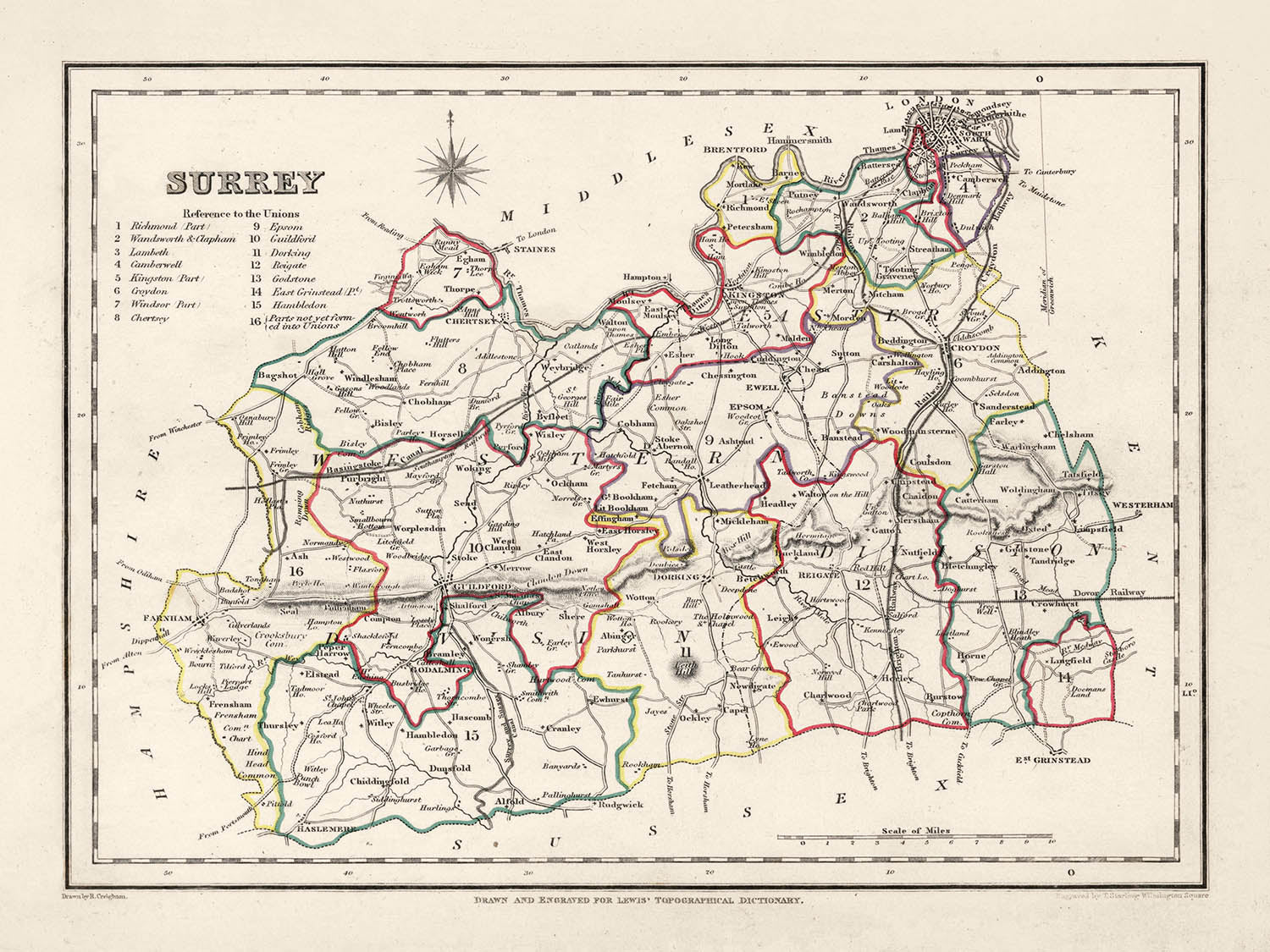


Antigua mapa de Surrey por Samuel Lewis, 1844: Londres, Guildford, Woking, Ewell y Camberley
Compra 2, Llévate 1 Gratis
Si añades 2 artículos a tu carrito, puedes añadir un tercer producto gratis.
Esto aplica a todos los mapas y obras de arte, incluyendo piezas personalizadas y personalizadas. Puedes pedir 3 de lo mismo, o 3 cosas diferentes.
Esto equivale a un descuento del 33%, que será el mayor descuento disponible en mi tienda este año.
¡Aprovecha la oferta y cubre tus paredes con hermosos mapas y arte!
Contáctame si tienes alguna pregunta.

-
![]() Handmade locally in the EU
Handmade locally in the EU
-
FREE worldwide delivery in 2-3 days ⓘ
Free delivery in 2-3 days
Your map should be delivered in 2-3 working days with free delivery, worldwide.
Deliveries over the Christmas and New Year period may be slightly delayed, as couriers and postal services catch up with a huge backlog of packages.
We make maps by hand locally in 23 countries, including the EU
![]() . If you're buying a gift for someone in another country, we will make the map locally to them.
. If you're buying a gift for someone in another country, we will make the map locally to them.You will never pay import tax or customs duty.
Express delivery is available at checkout which can reduce the delivery time to 1-2 days.
Please note that personalised maps, and larger framed maps, can take longer to produce and deliver.
If you need your order to arrive by a certain date, contact me and we can discuss your options.
-
FREE gift preview
ⓘ
Digital gift preview
After you complete your order, you can send a beautiful digital preview to the gift recipient. Just provide their email address and we'll do the rest. (Their email address will not be stored or used for any other purpose.)
This is perfect if you're concerned that your order might not arrive in time.
You can also buy a real non-expiring gift card, and email it directly to the recipient, so they can buy their own map or artwork.
-
90 day money back guarantee
ⓘ
90 días para devolver y reembolsar
Los productos se pueden devolver dentro de los 90 días para un reembolso completo, o cambio por otro producto.
Para artículos personalizados y hechos a medida, podemos ofrecerte crédito en la tienda o una tarjeta de regalo sin fecha de caducidad, ya que no podemos revender pedidos personalizados.
Si tienes alguna pregunta, ponte en contacto. Para más información, consulta nuestra política de devoluciones y cambios.

My maps are rare, museum-grade, restored old maps sourced from libraries, auction houses and private collections across the globe.
Framing & free personalisation available
1. Select your size
Click here to order a custom size.
2. Frame & personalise your map
Make your map unique with framing, hand-drawn customisation, vintage ageing, pop art text, unique 3D styling and more.


Mensaje de regalo y acabado personalizado

Si deseas agregar un mensaje de regalo, o un acabado (rompecabezas, tablero de aluminio, etc.) que no esté disponible aquí, por favor solicítalo en la "nota del pedido" cuando realices la compra.
Cada pedido es hecho a medida, así que si necesitas que el tamaño se ajuste ligeramente, o que se imprima en un material inusual, háznoslo saber. Hemos realizado miles de pedidos personalizados a lo largo de los años, así que hay (casi) nada que no podamos gestionar.
También puedes contactarnos antes de hacer tu pedido, ¡si lo prefieres!

- Handmade locally. No import duty or tax
- FREE worldwide delivery
- Love it or your money back (90 days)
- Questions? WhatsApp me any time
Own a piece of history
5,000+ 5 star reviews


Abrace una pieza de cartografía histórica con este impresionante mapa de Surrey de 1844 por Samuel Lewis. Esta obra de arte visualmente cautivadora es más que un simple relicario histórico; es un portal al pasado, que nos permite rastrear la evolución de algunas de las ciudades, pueblos y asentamientos más queridos de Inglaterra, que estaban arraigados en la historia incluso en el momento de la creación de este mapa.
Empapada en una rica historia, el pasado de Surrey se puede trazar fascinantemente a través de sus asentamientos. Este mapa de 1844 incluye lugares que prosperaban antes de 1840, algunos de los cuales han cambiado significativamente o incluso han cambiado de nombre. Por el contrario, es posible que encuentre la ausencia de algunos asentamientos modernos que aún no se habían fundado o reconocido. Esto crea una emocionante oportunidad para el descubrimiento y la comparación histórica.
Asentamientos
(en orden de tamaño de población actual):- Londres (43 d.C.): Establecida por los romanos como Londinium, fue una importante ciudad comercial y la capital provincial.
- Guildford (c. 970 d.C.): Hogar de una Casa de la Moneda Real desde el reinado del Rey Alfredo hasta la época de Guillermo el Conquistador.
- Woking (c. 1086 d.C.): Mencionada en el Libro Domesday como Wochinges, fue poseída por el Rey Guillermo.
- Ewell (antes de 775 d.C.): Conocida por sus restos romanos, incluyendo una villa y una casa de baños.
- Camberley (c. 1200 d.C.): Históricamente parte de un área conocida como Bagshot Heath, famosa por los bandidos de caminos en el siglo XVII.
- Redhill (c. 1818 d.C.): Originalmente un punto de parada en la carretera de Londres a Brighton durante el siglo XVIII.
- Reigate (c. 1088 d.C.): Hogar del Castillo de Reigate, que se cree que fue establecido poco después de la Conquista Normanda.
- Staines-upon-Thames (c. 100 d.C.): Una histórica ciudad de mercado que fue una vez el sitio de un puente romano.
- Sunbury-on-Thames (antes de 962 d.C.): Mencionada en la Crónica Anglo-Sajona, conocida por su ubicación junto al río.
- Banstead (antes de 1086 d.C.): Conocida por su historia en la agricultura, mencionada en el Libro Domesday.
- Epsom (antes de 1086 d.C.): El hogar de la Sal de Epsom y el Derby de Epsom.
- Farnham (c. 688 d.C.): Conocida por su paisaje urbano georgiano y un antiguo parque de ciervos.
- Dorking (c. 1086 d.C.): Hogar de Dorking Halls, un importante lugar para conciertos y películas.
- Chertsey (c. 666 d.C.): Conocida por su Abadía, que fue uno de los monasterios benedictinos más grandes de Inglaterra.
- Godalming (c. 880 d.C.): En 1881, se convirtió en la primera ciudad del mundo en tener un suministro público de electricidad.
- Haslemere (antes de 1221 d.C.): Conocida por su centro de la ciudad "georgiano y anterior".
- Caterham (antes de 1086 d.C.): Mencionada en el Libro Domesday y el hogar del fabricante de coches Caterham.
- Leatherhead (antes de 880 d.C.): Un cruce significativo en la ruta principal de Londres a la costa sur.
- Esher (antes de 1086 d.C.): Hogar del Jardín Paisajístico de Claremont, una propiedad notable del National Trust.
- Cobham (antes de 1086 d.C.): Conocida por sus edificios históricos, incluyendo el Molino de Cobham, un molino de agua de 1822.
- Walton-on-Thames (antes de 1086 d.C.): Sitio de un fuerte romano, la "Statio Albani," en la carretera militar a Londres.
- East Molesey (antes de 1086 d.C.): Hogar del Palacio de Hampton Court, construido para el Cardenal Thomas Wolsey a principios del siglo XVI.
- Ashtead (antes de 1086 d.C.): Conocida por su villa romana y fábricas de tejas excavadas en las décadas de 1920 y 1980.
Características Notables:
- El río Támesis, una vía fluvial importante en Inglaterra, notable por su papel en el comercio, el transporte y la recreación.
- Los North Downs, una cresta de colinas de tiza, parte de un Área de Belleza Natural Sobresaliente (AONB).
- Box Hill, una atracción turística popular con vistas panorámicas y fauna silvestre rara.
- El lago Virginia Water, ubicado en Windsor Great Park, popular por sus hermosos paisajes.
Eventos Históricos (1800-1850):
- La construcción del Ferrocarril de Londres a Southampton (1838), que llevó al rápido crecimiento de ciudades como Woking.
- La carrera inaugural del Epsom Derby, una prestigiosa carrera de caballos, en 1780 (con su carrera continua bien entrado el período estudiado).
Descubre, explora y enamórate de la encantadora historia de Surrey a través de este notable mapa de 1844 de Samuel Lewis. Una perfecta combinación de historia, arte y cultura, es verdaderamente una excelente adición a cualquier colección o un gran regalo para el apasionado amante de la historia.
Por favor, verifica las imágenes para asegurarte de que una ciudad o lugar específico esté mostrado en este mapa. También puedes ponerte en contacto y pedirnos que verifiquemos el mapa por ti.
Este mapa se ve genial en todos los tamaños: 8x10in (20.5x25.5cm), 12x16in (30.5x41cm), 18x24in (45.5x61cm), 16x20in (40.5x51cm), 24x36in (61x91.5cm), 30x40in (76x101.5cm) y 37x50in (94x127cm), pero se ve aún mejor cuando se imprime en grande.
Puedo crear impresiones grandes y hermosas de este mapa de hasta 50in (127cm). Por favor, contáctame si estás buscando opciones de enmarcado más grandes, personalizadas o diferentes.
El modelo en las imágenes del anuncio sostiene la versión de 18x24in (45.5x61cm) de este mapa.
La quinta imagen del anuncio muestra un ejemplo de mi servicio de personalización de mapas.
Si estás buscando algo ligeramente diferente, consulta mi colección principal de mapas del Reino Unido e Irlanda.
Por favor, contáctame para verificar si una ubicación, hito o característica específica está mostrada en este mapa.
Este sería un maravilloso regalo de cumpleaños, Navidad, Día del Padre, despedida laboral, aniversario o de inauguración de casa para alguien de las áreas cubiertas por este mapa.
Este mapa está disponible como una impresión giclée en papel mate libre de ácido y de archivo, o puedes comprarlo enmarcado. El marco es un bonito y simple marco negro que se adapta a la mayoría de las estéticas. Por favor, contáctame si deseas un color o material de marco diferente. Mis marcos están vidriados con acrílico de grado museo superclaro (perspex/acrylite), que es significativamente menos reflectante que el vidrio, más seguro y siempre llegará en perfectas condiciones.
This map is also available as a float framed canvas, sometimes known as a shadow gap framed canvas or canvas floater. The map is printed on artist's cotton canvas and then stretched over a handmade box frame. We then "float" the canvas inside a wooden frame, which is available in a range of colours (black, dark brown, oak, antique gold and white). This is a wonderful way to present a map without glazing in front. See some examples of float framed canvas maps and explore the differences between my different finishes.
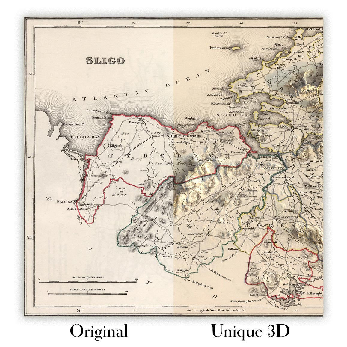
For something truly unique, this map is also available in "Unique 3D", our trademarked process that dramatically transforms the map so that it has a wonderful sense of depth. We combine the original map with detailed topography and elevation data, so that mountains and the terrain really "pop". For more info and examples of 3D maps, check my Unique 3D page.
Para la mayoría de los pedidos, el tiempo de entrega es de aproximadamente 3 días laborables. Los productos personalizados y a medida tardan más, ya que tengo que hacer la personalización y enviártelo para su aprobación, lo cual suele tardar 1 o 2 días.
Tenga en cuenta que los pedidos enmarcados muy grandes suelen tardar más en fabricarse y entregarse.
Si necesitas que tu pedido llegue para una fecha determinada, por favor contáctame antes de hacer el pedido para que podamos encontrar la mejor manera de asegurarnos de que recibas tu pedido a tiempo.
Imprimo y enmarco mapas y obras de arte en 23 países alrededor del mundo. Esto significa que tu pedido se fabricará localmente, lo que reduce el tiempo de entrega y asegura que no se dañe durante el envío. Nunca pagarás aranceles de aduana o impuestos de importación, y pondremos menos CO2 en el aire.
Todos mis mapas y impresiones artísticas están bien empaquetados y enviados en un tubo resistente si no están enmarcados, o rodeados de espuma si están enmarcados.
Intento enviar todos los pedidos dentro de 1 o 2 días después de recibir tu pedido, aunque algunos productos (como mascarillas, tazas y bolsas de tela) pueden tardar más en fabricarse.
Si seleccionas Entrega Exprés al finalizar la compra, priorizaremos tu pedido y lo enviaremos por mensajería de 1 día (Fedex, DHL, UPS, Parcelforce).
La entrega al día siguiente también está disponible en algunos países (EE. UU., Reino Unido, Singapur, EAU), pero por favor intenta hacer tu pedido temprano en el día para que podamos enviarlo a tiempo.
Mi marco estándar es un marco de madera de fresno negro estilo galería. Es simple y tiene un aspecto bastante moderno. Mi marco estándar tiene alrededor de 20 mm (0.8 in) de ancho.
Utilizo acrílico super claro (perspex/acrylite) para el vidrio del marco. Es más ligero y seguro que el vidrio, y se ve mejor, ya que la reflectividad es menor.
Seis colores de marco estándar están disponibles de forma gratuita (negro, marrón oscuro, gris oscuro, roble, blanco y oro antiguo).El enmarcado y montaje/matizado personalizado está disponible si buscas algo diferente.
La mayoría de los mapas, arte e ilustraciones también están disponibles como un lienzo enmarcado. Utilizamos lienzo de algodón mate (no brillante), lo estiramos sobre un marco de madera de caja de origen sostenible, y luego 'flotamos' la pieza dentro de un marco de madera. El resultado final es bastante hermoso, y no hay cristal que se interponga.
Todos los marcos se proporcionan "listos para colgar", con una cuerda o soportes en la parte posterior. Los marcos muy grandes tendrán placas de colgar de alta resistencia y/o un listón de montaje. Si tienes alguna pregunta, por favor ponte en contacto.
Mira algunos ejemplos de mis mapas enmarcados y mapas en lienzo enmarcados.
Alternativamente, también puedo proporcionar mapas antiguos y obras de arte en lienzo, tablero de espuma, papel de algodón y otros materiales.
Si deseas enmarcar tu mapa o obra de arte tú mismo, por favor lee mi guía de tamaños primero.
Algunos de mis mapas antiguos ahora están disponibles como lienzos enmarcados. Por favor contáctame si deseas pedir un tamaño que no está disponible en mi tienda.
Los mapas antiguos en lienzo son una alternativa interesante a los mapas enmarcados convencionalmente. Dependiendo de tu gusto personal y la decoración de la habitación, los mapas en lienzo pueden "destacar" un poco más que un mapa enmarcado.
Mis mapas son reproducciones de mapas originales de altísima calidad.
Obtengo mapas originales y raros de bibliotecas, casas de subastas y colecciones privadas de todo el mundo, los restauro en mi taller de Londres y luego uso tintas e impresoras giclée especializadas para crear hermosos mapas que lucen incluso mejor que el original.
Mis mapas están impresos en papel de archivo mate (no brillante) sin ácido que se siente de muy alta calidad y casi como una tarjeta. En términos técnicos, el peso/grosor del papel es de 10 mil/200 g/m². Es perfecto para enmarcar.
Imprimo con tintas pigmentadas Epson ultrachrome giclée UV resistentes a la decoloración, algunas de las mejores tintas que puedes encontrar.
yo también puedo hacer mapas sobre lienzo, trapo de algodón y otros materiales exóticos.
Obtenga más información sobre The Unique Maps Co..
Personalización de mapas
Si está buscando el regalo perfecto de aniversario o inauguración de la casa, puedo personalizar su mapa para hacerlo verdaderamente único. Por ejemplo, puedo agregar un mensaje corto, resaltar una ubicación importante o agregar el escudo de armas de su familia.
Las opciones son casi infinitas. Por favor mira mi página de personalización de mapas para ver algunos maravillosos ejemplos de lo que es posible.
Para pedir un mapa personalizado, seleccione "personalizar su mapa" antes de agregarlo a su carrito.
Ponerse en contacto si buscas personalizaciones y personalizaciones más complejas.
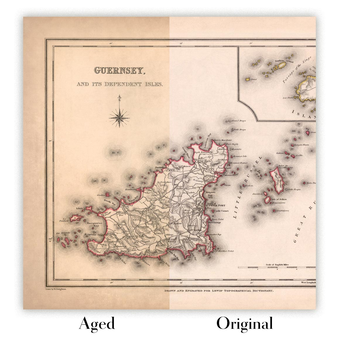
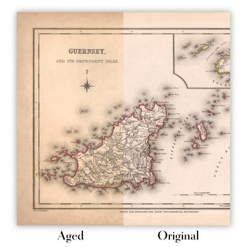
Envejecimiento del mapa
A lo largo de los años, los clientes me han preguntado cientos de veces si podían comprar un mapa que se viera uniforme. más viejo.
Bueno, ahora puedes hacerlo seleccionando Envejecido antes de agregar un mapa a tu carrito.
Todas las fotografías de productos que ve en esta página muestran el mapa en su forma original. Así es como se ve el mapa hoy.
Si selecciona Envejecido, envejeceré su mapa a mano, usando un proceso especial y único desarrollado a través de años de estudiar mapas antiguos, hablar con investigadores para comprender la química del envejecimiento del papel y, por supuesto... ¡mucha práctica!
Si no estás seguro, quédate con el color original del mapa. Si quieres algo un poco más oscuro y más viejo buscando, opte por Envejecido.
Si no estás satisfecho con tu pedido por cualquier motivo, contáctame para un reembolso sin complicaciones. Por favor, consulta nuestra política de devoluciones y reembolsos para más información.
Estoy muy seguro de que te gustará tu mapa o impresión artística restaurada. He estado haciendo esto desde 1984. Soy un vendedor de 5 estrellas en Etsy. He vendido decenas de miles de mapas e impresiones artísticas y tengo más de 5,000 opiniones reales de 5 estrellas.
Utilizo un proceso único para restaurar mapas y obras de arte que consume mucho tiempo y mano de obra. Buscar los mapas e ilustraciones originales puede llevar meses. Utilizo tecnología de última generación y extremadamente cara para escanear y restaurarlos. Como resultado, garantizo que mis mapas e impresiones artísticas son superiores a los demás - por eso puedo ofrecer un reembolso sin complicaciones.
Casi todos mis mapas e impresiones artísticas se ven increíbles en tamaños grandes (200cm, 6.5ft+) y también puedo enmarcarlos y entregártelos a través de un servicio de mensajería especial para tamaños grandes. Contáctame para discutir tus necesidades específicas.
Or try searching for something!


