


Antigua Mapa Mundial de Mercator Mostrando los Descubrimientos del Capitán Cook por Carey, 1814: Centrado en el Pacífico

-
![]() Handmade locally in the EU
Handmade locally in the EU
-
Christmas delivery: check the deadline
Free delivery in 2-3 days
Your map should be delivered in 2-3 working days with free delivery, worldwide.
Please order by 11am ET Monday with Next Day delivery at checkout for Christmas delivery. Canvases will not arrive for Christmas. Unframed orders have a better chance of arriving in time.
New for 2024: You can send a beautiful gift preview by email, if you think your order won't arrive on time.
We make maps by hand locally in 23 countries, including the EU
![]() . If you're buying a gift for someone in another country, we will make the map locally to them.
. If you're buying a gift for someone in another country, we will make the map locally to them.You will never pay import tax or customs duty.
Some orders are now taking 5-6 days to arrive because of postal slowdowns. Please order soon to ensure you get your order before Christmas. Check my Christmas delivery guide for more info.
Express delivery is available at checkout which can reduce the delivery time to 1-2 days.
Please note that personalised maps, and larger framed maps, can take longer to produce and deliver.
If you need your order to arrive by a certain date, contact me and we can discuss your options.
-
90 day money back guarantee
ⓘ
90 días para devolver y reembolsar
Los productos se pueden devolver dentro de los 90 días para un reembolso completo, o cambio por otro producto.
Para artículos personalizados o hechos a medida, podemos ofrecerte un crédito en la tienda o una tarjeta de regalo que no caduca, ya que no podemos revender pedidos personalizados.
Si tienes alguna pregunta, ponte en contacto. Para más información, consulta nuestra política de devoluciones y cambios.

My maps are rare, museum-grade, restored old maps sourced from libraries, auction houses and private collections across the globe.
Framing & free personalisation available
1. Select your size
2. Frame & personalise your map
Make your map unique with framing, hand-drawn customisation, vintage ageing, pop art text, unique 3D styling and moreMensaje de regalo y acabado personalizado

Si deseas agregar un mensaje de regalo, o un acabado (rompecabezas, tablero de aluminio, etc.) que no esté disponible aquí, por favor solicítalo en la "nota del pedido" cuando realices la compra.
Cada pedido es hecho a medida, así que si necesitas que el tamaño se ajuste ligeramente, o que se imprima en un material inusual, háznoslo saber. Hemos realizado miles de pedidos personalizados a lo largo de los años, así que hay (casi) nada que no podamos gestionar.
También puedes contactarnos antes de hacer tu pedido, ¡si lo prefieres!

- Handmade locally. No import duty or tax
- FREE Delivery. Arrives in 2-3 days
- Love it or your money back
- Questions? WhatsApp me any time
Own a piece of history
5,000+ 5 star reviews


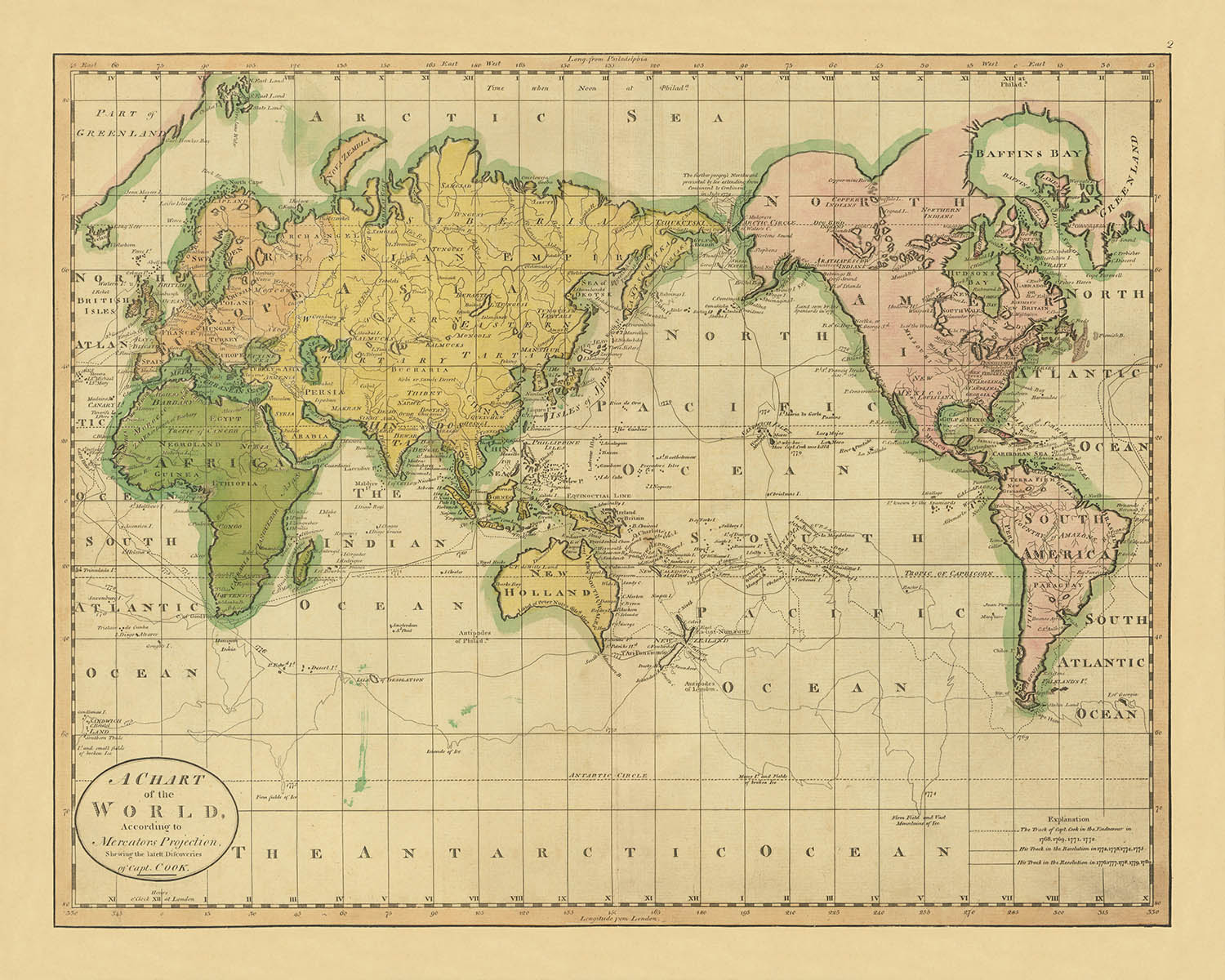
Adéntrese en el cautivador mundo de la exploración a principios del siglo XIX con "Un Mapa del Mundo Según la Proyección de Mercator. Mostrando los últimos Descubrimientos del Capitán Cook." Creado por el estimado cartógrafo estadounidense Mathew Carey en 1814, este mapa es un testimonio de la era de los descubrimientos y el espíritu de aventura. Como uno de los primeros mapas mundiales impresos en América, captura la esencia de una época en la que el mundo aún estaba siendo cartografiado y comprendido. La obra de Carey es un reflejo de la creciente tradición cartográfica americana, combinando arte con indagación científica.
El mapa es una narrativa visual de los legendarios viajes del Capitán James Cook, meticulosamente trazados con líneas distintas que siguen sus rutas a través del globo. Estos viajes, que expandieron los límites de la geografía conocida, están inmortalizados aquí, ofreciendo un vistazo a los desafíos y triunfos de la exploración. El mapa no solo documenta los caminos de Cook, sino que también destaca áreas del mundo que aún estaban envueltas en misterio, invitando a los espectadores a imaginar los territorios inexplorados que yacían más allá.
Diseñado utilizando la proyección de Mercator, el mapa presenta una mezcla armoniosa de atractivo estético y precisión funcional. Su coloración original, una rareza para los mapas de este período, añade una capa de riqueza y profundidad, realzando su atractivo visual. El estilo del mapa recuerda a las ediciones encontradas en la Geografía de Guthrie, sugiriendo un linaje compartido en las planchas utilizadas para la impresión. Esta conexión subraya la naturaleza colaborativa de la cartografía durante este tiempo, ya que los cartógrafos se basaban en el trabajo de los demás para refinar y expandir la comprensión del mundo.
Los detalles geográficos en el mapa revelan el conocimiento en evolución de la época. La Tierra de Van Diemen se representa como parte de Australia, mientras que la forma primitiva de Nueva Zelanda insinúa las etapas nacientes de su representación cartográfica. La costa noroeste de América y las regiones árticas están marcadas con líneas conjeturales, reflejando la limitada exploración de estas áreas. Anotaciones sobre campos de hielo alrededor del Círculo Antártico y el punto más al norte de Cook en julio de 1779 añaden capas de contexto histórico, convirtiendo el mapa en un rico tapiz de narrativas de exploración.
Este mapa es más que una representación del mundo; es un artefacto histórico que encapsula el espíritu del descubrimiento. Invita al espectador a viajar de regreso a una época en la que el mundo aún se estaba desvelando, un viaje a la vez. Ya sea que sea un coleccionista, un entusiasta de la historia o simplemente esté cautivado por el arte de la cartografía, este mapa ofrece una ventana única al pasado, donde cada línea y anotación cuenta una historia de aventura, curiosidad y la incansable búsqueda del conocimiento.
Países y regiones en este mapa
- Continentes:
- América del Norte
- América del Sur
- Europa
- África
- Asia
- Australia
- Regiones:
- Groenlandia
- Tierra de Van Diemen (Tasmania)
- Nueva Zelanda
- Costa Noroeste de América
- Círculo Ártico
- Círculo Antártico
Características y Monumentos Notables
- Cuerpos de agua:
- El Océano Ártico, el Océano Atlántico, el Océano Índico y el Océano Pacífico están etiquetados.
- Notas históricas:
- Las rutas del Capitán Cook están marcadas con diferentes tipos de líneas.
- Anotaciones sobre el punto más al norte de Cook en julio de 1779.
- Campos de hielo encontrados alrededor del Círculo Antártico.
- Otras características:
- El mapa incluye una explicación de las líneas utilizadas para denotar los viajes de Cook.
- Anotaciones sobre incertidumbres geográficas y áreas conjeturales.
Contexto histórico y de diseño
- Creado por: Mathew Carey en 1814.
- Significado histórico:
- Uno de los primeros mapas mundiales impresos en América.
- Refleja el conocimiento geográfico y las exploraciones de principios del siglo XIX.
- Diseño y estilo:
- Utiliza la proyección de Mercator.
- Presenta color original, lo cual es raro en mapas de este período.
- Similar a una edición en la Geografía de Guthrie, posiblemente impresa desde la misma placa.
- Temas y tópicos:
- Exploración y descubrimiento, destacando los viajes del Capitán Cook.
- El mapa incluye áreas conjeturales, reflejando el conocimiento limitado de ciertas regiones en ese momento.
Por favor, verifica las imágenes para asegurarte de que una ciudad o lugar específico esté mostrado en este mapa. También puedes ponerte en contacto y pedirnos que revisemos el mapa por ti.
Este mapa se ve genial en cualquier tamaño, pero siempre recomiendo optar por un tamaño más grande si tienes espacio. De esa manera, puedes distinguir fácilmente todos los detalles.
Este mapa se ve increíble en tamaños de hasta 70in (180cm). Si estás buscando un mapa más grande, por favor ponte en contacto.
El modelo en las imágenes de la lista sostiene la versión de este mapa de 16x20in (40x50cm).
La quinta imagen de la lista muestra un ejemplo de mi servicio de personalización de mapas.
Si buscas algo ligeramente diferente, echa un vistazo a mi colección de los mejores mapas antiguos para ver si algo más llama tu atención.
Por favor contáctame para verificar si una ubicación, hito o característica específica está mostrada en este mapa.
Este sería un maravilloso regalo de cumpleaños, Navidad, Día del Padre, despedida laboral, aniversario o de inauguración de casa para alguien de las áreas cubiertas por este mapa.
Este mapa está disponible como una impresión giclée en papel mate libre de ácido y de archivo, o puedes comprarlo enmarcado. El marco es un bonito y simple marco negro que se adapta a la mayoría de las estéticas. Por favor, ponte en contacto si deseas un color o material de marco diferente. Mis marcos están envidriados con acrílico de grado museo superclaro (perspex/acrylite), que es significativamente menos reflectante que el vidrio, más seguro, y siempre llegará en perfectas condiciones.
This map is also available as a float framed canvas, sometimes known as a shadow gap framed canvas or canvas floater. The map is printed on artist's cotton canvas and then stretched over a handmade box frame. We then "float" the canvas inside a wooden frame, which is available in a range of colours (black, dark brown, oak, antique gold and white). This is a wonderful way to present a map without glazing in front. See some examples of float framed canvas maps and explore the differences between my different finishes.
For something truly unique, this map is also available in "Unique 3D", our trademarked process that dramatically transforms the map so that it has a wonderful sense of depth. We combine the original map with detailed topography and elevation data, so that mountains and the terrain really "pop". For more info and examples of 3D maps, check my Unique 3D page.
Para la mayoría de los pedidos, el tiempo de entrega es de aproximadamente 3 días laborables. Los productos personalizados y a medida tardan más, ya que tengo que hacer la personalización y enviártelo para su aprobación, lo cual suele tardar 1 o 2 días.
Tenga en cuenta que los pedidos enmarcados muy grandes suelen tardar más en fabricarse y entregarse.
Si necesitas que tu pedido llegue para una fecha determinada, por favor contáctame antes de hacer el pedido para que podamos encontrar la mejor manera de asegurarnos de que recibas tu pedido a tiempo.
Imprimo y enmarco mapas y obras de arte en 23 países alrededor del mundo. Esto significa que tu pedido se fabricará localmente, lo que reduce el tiempo de entrega y asegura que no se dañe durante el envío. Nunca pagarás aranceles de aduana o impuestos de importación, y pondremos menos CO2 en el aire.
Todos mis mapas y impresiones artísticas están bien empaquetados y enviados en un tubo resistente si no están enmarcados, o rodeados de espuma si están enmarcados.
Intento enviar todos los pedidos dentro de 1 o 2 días después de recibir tu pedido, aunque algunos productos (como mascarillas, tazas y bolsas de tela) pueden tardar más en fabricarse.
Si seleccionas Entrega Exprés al finalizar la compra, priorizaremos tu pedido y lo enviaremos por mensajería de 1 día (Fedex, DHL, UPS, Parcelforce).
La entrega al día siguiente también está disponible en algunos países (EE. UU., Reino Unido, Singapur, EAU), pero por favor intenta hacer tu pedido temprano en el día para que podamos enviarlo a tiempo.
Mi marco estándar es un marco de madera de fresno negro estilo galería. Es simple y tiene un aspecto bastante moderno. Mi marco estándar tiene alrededor de 20 mm (0.8 in) de ancho.
Utilizo acrílico super claro (perspex/acrylite) para el vidrio del marco. Es más ligero y seguro que el vidrio, y se ve mejor, ya que la reflectividad es menor.
Seis colores de marco estándar están disponibles de forma gratuita (negro, marrón oscuro, gris oscuro, roble, blanco y oro antiguo).El enmarcado y montaje/matizado personalizado está disponible si buscas algo diferente.
La mayoría de los mapas, arte e ilustraciones también están disponibles como un lienzo enmarcado. Utilizamos lienzo de algodón mate (no brillante), lo estiramos sobre un marco de madera de caja de origen sostenible, y luego 'flotamos' la pieza dentro de un marco de madera. El resultado final es bastante hermoso, y no hay cristal que se interponga.
Todos los marcos se proporcionan "listos para colgar", con una cuerda o soportes en la parte posterior. Los marcos muy grandes tendrán placas de colgar de alta resistencia y/o un listón de montaje. Si tienes alguna pregunta, por favor ponte en contacto.
Mira algunos ejemplos de mis mapas enmarcados y mapas en lienzo enmarcados.
Alternativamente, también puedo proporcionar mapas antiguos y obras de arte en lienzo, tablero de espuma, papel de algodón y otros materiales.
Si deseas enmarcar tu mapa o obra de arte tú mismo, por favor lee mi guía de tamaños primero.
Algunos de mis mapas antiguos ahora están disponibles como lienzos enmarcados. Por favor contáctame si deseas pedir un tamaño que no está disponible en mi tienda.
Los mapas antiguos en lienzo son una alternativa interesante a los mapas enmarcados convencionalmente. Dependiendo de tu gusto personal y la decoración de la habitación, los mapas en lienzo pueden "destacar" un poco más que un mapa enmarcado.
Mis mapas son reproducciones de mapas originales de altísima calidad.
Obtengo mapas originales y raros de bibliotecas, casas de subastas y colecciones privadas de todo el mundo, los restauro en mi taller de Londres y luego uso tintas e impresoras giclée especializadas para crear hermosos mapas que lucen incluso mejor que el original.
Mis mapas están impresos en papel de archivo mate (no brillante) sin ácido que se siente de muy alta calidad y casi como una tarjeta. En términos técnicos, el peso/grosor del papel es de 10 mil/200 g/m². Es perfecto para enmarcar.
Imprimo con tintas pigmentadas Epson ultrachrome giclée UV resistentes a la decoloración, algunas de las mejores tintas que puedes encontrar.
yo también puedo hacer mapas sobre lienzo, trapo de algodón y otros materiales exóticos.
Obtenga más información sobre The Unique Maps Co..
Personalización de mapas
Si está buscando el regalo perfecto de aniversario o inauguración de la casa, puedo personalizar su mapa para hacerlo verdaderamente único. Por ejemplo, puedo agregar un mensaje corto, resaltar una ubicación importante o agregar el escudo de armas de su familia.
Las opciones son casi infinitas. Por favor mira mi página de personalización de mapas para ver algunos maravillosos ejemplos de lo que es posible.
Para pedir un mapa personalizado, seleccione "personalizar su mapa" antes de agregarlo a su carrito.
Ponerse en contacto si buscas personalizaciones y personalizaciones más complejas.
Envejecimiento del mapa
A lo largo de los años, los clientes me han preguntado cientos de veces si podían comprar un mapa que se viera uniforme. más viejo.
Bueno, ahora puedes hacerlo seleccionando Envejecido antes de agregar un mapa a tu carrito.
Todas las fotografías de productos que ve en esta página muestran el mapa en su forma original. Así es como se ve el mapa hoy.
Si selecciona Envejecido, envejeceré su mapa a mano, usando un proceso especial y único desarrollado a través de años de estudiar mapas antiguos, hablar con investigadores para comprender la química del envejecimiento del papel y, por supuesto... ¡mucha práctica!
Si no estás seguro, quédate con el color original del mapa. Si quieres algo un poco más oscuro y más viejo buscando, opte por Envejecido.
Si no estás satisfecho con tu pedido por cualquier motivo, contáctame para un reembolso sin complicaciones. Por favor, consulta nuestra política de devoluciones y reembolsos para más información.
Estoy muy seguro de que te gustará tu mapa o impresión artística restaurada. He estado haciendo esto desde 1984. Soy un vendedor de 5 estrellas en Etsy. He vendido decenas de miles de mapas e impresiones artísticas y tengo más de 5,000 opiniones reales de 5 estrellas.
Utilizo un proceso único para restaurar mapas y obras de arte que consume mucho tiempo y mano de obra. Buscar los mapas e ilustraciones originales puede llevar meses. Utilizo tecnología de última generación y extremadamente cara para escanear y restaurarlos. Como resultado, garantizo que mis mapas e impresiones artísticas son superiores a los demás - por eso puedo ofrecer un reembolso sin complicaciones.
Casi todos mis mapas e impresiones artísticas se ven increíbles en tamaños grandes (200cm, 6.5ft+) y también puedo enmarcarlos y entregártelos a través de un servicio de mensajería especial para tamaños grandes. Contáctame para discutir tus necesidades específicas.
Or try searching for something!


